After getting a better handle on how to share this blog with others (thanks to our daughters, Allison and Jordan); getting our decals on the dinghy (decals on the boat will occur at a later time when humidity and temps are down); studying the navigation systems (radar, wind charts, tide charts, weather reports, water depth and temperatures, alarm systems); learning how to use the washer/dryer combo, microwave, and stove/oven; getting comfortable with fueling, watering, dump-out systems; and going through the checklist of items for taking off tomorrow, an important question occurred to us at the end of the day (as we were patting ourselves on our backs for all our hard work learning all this new stuff): HOW DO WE START THE BOAT?
It was a sleepless night for Brenda. Mike--who enjoyed (several) IPA served at Pincher's Restaurant the night prior, slept just fine.
Despite the morning's wind, clouds and rain, we delved into studying the Mainship 400 manual for properly starting the engine. Next, we needed to determine our route plan for the day. After reviewing feedback we received regarding our plans to Demopolis, AL from other "Loopers" through the American Great Loop Cruising Association (AGLCA), we decided noon would be a good ETD and anchoring (need to learn how to do) near an island on the GCICW (Gulf Coast Intercoastal Waterway) south of Port Charlotte Sound would be a good place to stay the night. We will travel north and be ready to cross the Gulf by Friday when we should have a good "weather window" for cruising the big water. After a late breakfast, we made preparations to depart by going through the checklist we studied yesterday. The water was rough in the marina. More rain clouds were in the sky. Were we really going to do this?
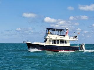
With Brenda at the helm and Mike on deck or dock and both of us with our earbuds connected to our cell phones to communicate with one another, we slowly left Legacy Harbor Marina without incident at 12:15 pm. Using Aquamaps, Navnet radar, Furuno gauges, Simrad auto pilot and the like, we cruised at approximately 7 miles per hour the waters of Florida depending on waterway signs and these technologies. The boat traffic was heavy in certain areas, but for the most part there was little traffic. We're taking turns at the helm so we can each work on other trip-related tasks (examples: blogging for Brenda; studying the radar systems more thoroughly for Mike).
Winds are from the SW at 14-16 mph; we're okay in regards to the tidal changes; no rain forecasted for the rest of the day. Later, we'll check out how to use our brand new, 35-lb plow anchor!
 |
| Mike's doing the finishing touches in applying the decals with the name of the boat and hailing port. |
 |
| This is our new anchor which we has already given us added confidence! |
 |
| "Velsignet" is ready for cruising. |
 |
| Mike on his boat; he's a happy captain! |
 |
| Meet the admiral! |


Comments
Post a Comment
We would love to hear your comments!