So our dear friend, Guy Falskow, calls this morning and shares with Brenda about the summer of 1954 when he spent time in Cape May. About that time, Brenda is also communicating with her cousins Cathy (NYC), Lisa (Visiting NYC from Spokane, WA) and goddaughter, Jamie (NYC) about getting together this next week. Throughout the day, we are texting with Loopers Liz and Steve, Penny and Dave, and Deb and Marty about plans in the coming days...can we meet up again? We email Mike's sister, Carol, who is in the midst of purchasing a lake home. Brenda and Erica Ellis text back and forth about "Delmarva Peninsula" and Michener books. We make a call to Jordan: Would the Stow family be going to the Finkenbinder Reunion this weekend? We text our Colorado granddaughter for the first time on her own cell phone. Brenda and Val Wagner text back and forth about wedding plans for Val and Bob's daughter, Laura. This evening, Mike catches up with our Long Lake, MN friend Donna.
THIS is what the Loop's about: The Human connections we make and share with along the way!
Docked at Utsch's Marina, this morning we did as best we could to plan for New York City (This means looking at the weather AGAIN, making phone calls to marinas, texting folks we hope to get together with, and taking inventory of water, fuel and groceries). We've decided to leave Cape May tomorrow morning (Sunday) around 11 am and cruise "outside" onto the Atlantic. Rather than take the narrow and shallow Jersey ICW and stop at Atlantic City, we will "do an overnight" voyage about 1 mile off the coast on the ocean, skip past the rest of the New Jersey Shore to arrive at New York Harbor around 9 am on Monday morning.
Tonight-- we rest up!
 |
| This is the beach at Cape May Point State Park. No swimming allowed! (Really?) The State Park's museum let us know that New Jersey is the home of several snakes. It's also a great place for birding. |
 |
| We were on the dock by 7 a.m. to see off "Stay Strong" with captains Deb and Marty and crew members Kevin and Vaneesa. They departed for Atlantic City, NJ and we hope to see them again on the Hudson! |
 |
Mike completed a job that we've had on our "to do" list for some time: weatherproofing the canvas. We see how the Scotchguard waterseal works.
When the grandkids visited (and slept in the fly bridge), we used a canvas to keep the flybridge area dry. |
 |
| This is at the Point of Cape May where the Delaware meets the Atlantic Ocean. The object in the water is the remains of an experimental concrete ship, one of 12 that were built during WWI. Proven impractical because of its weight, the ship was purchased and used as a ferry dock in Cape May. On June 8th, 1926, a storm broke the ship from its moorings and it ran aground. Attempts to free the sunken vessel were unsuccessful. |
 |
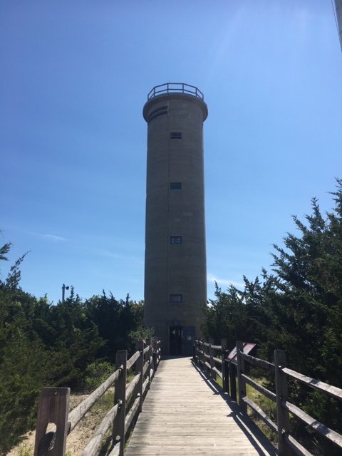
This is Fire Control Tower #23. This tower was built to house a sophisticated system for aiming the guns of Fort Miles towards enemy ships during WWII. When a target was spotted, a bell would ring at regular intervals, enabling the reader and plotter working an azimuth (binocular-like instrument that--using the geometric principle of triangulation, gave the precise angle between the ship and a base line) to predict the location of the ship a few seconds in advance.
|
 |
In 1890, the Shoreham Hotel was built, complete with 150 rooms. In 1909, the Sisters of St. Joseph purchased the hotel and renamed it to "St. Mary's By-the-Sea" to be used for summer retreats. During WWII, the sisters leased it to the government and mean camped on the grounds around it.
|
 |
This is the Cape May Lighthouse. It was built in 1859, automated in 1946, and became the responsibility of the US Coast Guard in 1992. It continues to be an active aid to maritime navigation.
While Guy Falskow was ashore living at the Coast Guard Station, he was up in the Lighthouse doing some triangulation to draw charts they didn't have to plot the location of their ship. With a master and two slave radio stations set up on the beach that sent out signals which were used to plot their location. They also had a recording fathometer on the ship. From this data, they could draw topographic maps of the bottom of the ocean. |
 |
| This is Battery 223, a harbor defense battery built during WWII on the Point at Cape May near the Lighthouse. |
 |
| This is Mike with the Cape May Point State Park in the background. |
 |
| Here's Mike as he catches up with Donna and Karin on the phone. |


This highly anticipated blog is one of our day's highlights, Brenda. We miss you both and look forward to a reunion when possible. What wonderful experiences you're having. God's speed, dear friends💕.
ReplyDeleteWe are glad that we can keep friends and family in the know of where we are and what we’re doing. We miss you, too, Karin....this time of year we’d be in our rangers playing in the woods and the mud!
Delete